JELLY BEAN GENIUS
Israel Map Poster 11x17 | Laminated Double-Sided Geography Chart with Color Map Front & Blank Outline Back | Reusable Classroom & Homeschool Learning Tool
Free shipping with 3 or more products in your cart
Alternative sizes, colours, or choices are currently unavailable.
Payflex: Pay in 4 interest-free payments of R193.75. Read the FAQ
R 775
In stock
Low stock in USA warehouse Order soon to secure your order
Used, Good Condition
Duties, insurance and VAT included
Delivered in 10–20 working days —
Free shipping with 3 or more products in your cart
Secure checkout
Your payment is fully protected
Duties & VAT included
No surprise charges at the door
Tracked delivery
Track your order end to end
Returns support
30-day return window
Description
Condition - Very Good
The item shows wear from consistent use but remains in good condition. It may arrive with damaged packaging or be repackaged.
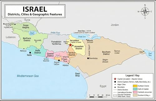
- DOUBLE-SIDED ISRAEL MAP: Side A features a vibrant, full-color map of Israel showing all six districts, major cities, historical regions, and the Dead Sea. Side B includes a blank outline map for practice, labeling, and review.
- BUILT FOR GEOGRAPHY LEARNING: Includes key locations such as Jerusalem, Tel Aviv, Haifa, Beersheba, and Eilat, along with geographic features like the Jordan River, Dead Sea, Negev Desert, and Sea of Galilee.
- PREMIUM LAMINATED, REUSABLE SURFACE: Durable laminated finish protects against wear and allows easy write-on/wipe-off use with dry-erase markers, making it ideal for repeated practice, quizzes, and study sessions.
- VERSATILE FOR HOME & CLASSROOM USE: Well suited for homeschool lessons, classrooms, study areas, and geography instruction. The 11x17 size fits desks, binders, and wall displays without taking up excess space.
- DESIGNED & PRINTED IN THE USA: Designed and manufactured in the United States using globally sourced materials, with crisp printing and consistent quality you can rely on.
Technical Specifications
Manufacturer
JAMS Publishing LLC
Color
Israel
Size
43.2 cmL x 27.9 cmW
Shipping & Delivery
Your order is shipped from the USA and delivered to your door in South Africa in 10–20 working days. All items are fully tracked.
Returns & Exchanges
We offer a 30-day return window. If something isn't right, contact our support team and we'll make it right.