
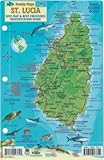
Saint Lucia Street Map With Index 1:45,000
Product Description
Condition - Very Good
The item shows wear from consistent use but remains in good condition. It may arrive with damaged packaging or be repackaged.
Saint Lucia Street Map With Index 1:45,000
- Attractive full color layout;
- Rich topographic detail;
- Symbol key, scale, and street index;
- Insets of 4 main cities – including the capital, main and secondary roads, hiking trails, diving sites, shipwrecks, aircraft wreck, airports, geological formations, marine parks, churches, cemeteries, beaches, protected zones, ports, and other points of interest;
- Depth curves, soundings in meters, longitude and latitude lines and other identifiers.
This first and only complete road map with a place index of Saint Lucia ( Scale 1 : 45 000 ) renders all the island's known roads and streets with their names, locates hiking trails and diving sites, and provides insets for the major urban areas: Castries capital, Gros Islet, Soufrière, and Vieux Fort. *** The map is sold folded, measuring 5 1/4" x 7 3/4" ( 13.5 cm x 19.5 cm ), and is designed for easy opening and refolding. Its full unfolded format is 26 3/8" x 38 1/2" ( 67 cm x 98 cm ).
Technical Specifications
You might also like
Insight Guides Pocket St Lucia (Travel Guide with Free eBook) (Insight Pocket Guides)

101 Things To Do And Places To See In Saint Lucia
St. Lucia Dive Map & Reef Creatures Guide Franko Maps Laminated Fish Card

The Rough Guides' St. Lucia Directions (Rough Guide Directions)
Fodor's In Focus Barbados & St. Lucia (Full-color Travel Guide)

Saint-Lucia Road Map Gizi 1: 50 000 (English and French Edition) Gizi (ROAD MAP - 1/50.000)

1. Saint Lucia & Martinique Travel Reference Map 1:45k /1:65k

St. Martin Road Map w/ Street Index, Hiking Trails, Biking Routes and Diving Sites - 2017 Edition (English and French Edition) (CARTES)

Wildlife of the Caribbean (Princeton Pocket Guides)